DRE-Tasmania-logo

Cohga Secures Contract with Tasmanian Government for ACHRIS Implementation

Contract Awarded

In a significant milestone for cultural heritage management, Cohga has entered into a contract with the Tasmanian Government to implement their Aboriginal Cultural Heritage Information System '(ACHRIS), a comprehensive solution for managing Aboriginal heritage. The partnership represents a pivotal step forward in preserving Tasmania’s rich Aboriginal heritage and underscores Cohga’s unwavering commitment to delivering cutting-edge technology for cultural heritage management.

Aboriginal Heritage Register

The Aboriginal Heritage Register (AHR) is a vital database that houses information about over 13,000 significant places and objects related to the Aboriginal people of Tasmania. Although not publicly accessible due to its culturally sensitive content, the AHR serves several essential functions. These include collecting and managing site data, providing access to this information, offering legislative advice on heritage matters, assisting with compliance, and handling system administration and reporting. Initially developed in 2013 as part of proposed changes to the Aboriginal Heritage Act 1975, the AHR has encountered challenges due to the non-passage of expected updates, resulting in a system that is difficult to enhance and maintain.

Proven Solution

ACHRIS, Cohga’s Indigenous Heritage Information Management System, tackles these challenges by providing a web application that seamlessly integrates forms-based workflows with a spatial system. This enables staff, key stakeholders, and the public to query, report, and manage cultural heritage information within a single, user-friendly, spatially-enabled environment. Not only does the system enhance the efficiency of managing cultural heritage data, but it also ensures the preservation and protection of culturally significant information.

Proven Partnership

Cohga’s partnership with the Tasmanian Government underscores the company’s proven history of collaboration with government agencies throughout Australia. ACHRIS, along with its platform Weave, has been successfully deployed as cultural heritage databases and registers in three Australian states, with Tasmania being the fourth. These implementations serve as compelling evidence of Cohga’s capacity to provide efficient and user-friendly access to cultural heritage information, all while adhering to the requirements of the relevant Cultural Heritage Acts.

"We are thrilled to collaborate with the Tasmanian Government in implementing ACHRIS," said Aaron Van Herk, Cohga Director. "This partnership not only reinforces our commitment to preserving Aboriginal heritage but also highlights the strengths of the partnerships we have built with various government agencies. We provide a robust, adaptable, and user-friendly system that meets the specific needs of cultural heritage management."

Summary

The implementation of ACHRIS in Tasmania will be completed within this financial year. This significant milestone will significantly enhance the management of Aboriginal heritage information, ensuring its preservation for future generations while making it accessible to those who need it. Cohga remains committed to building strong partnerships with government agencies and leveraging technology to protect and manage Australia’s invaluable cultural heritage.

For more information about Cohga and its innovative solutions for cultural heritage management, please visit our website https://www.cohga.com/solutions/indigenous-heritage-management/.

carbon-calculator

Introducing the Weave Raster Inquiry Tool

Weave Raster Inquiry Tool

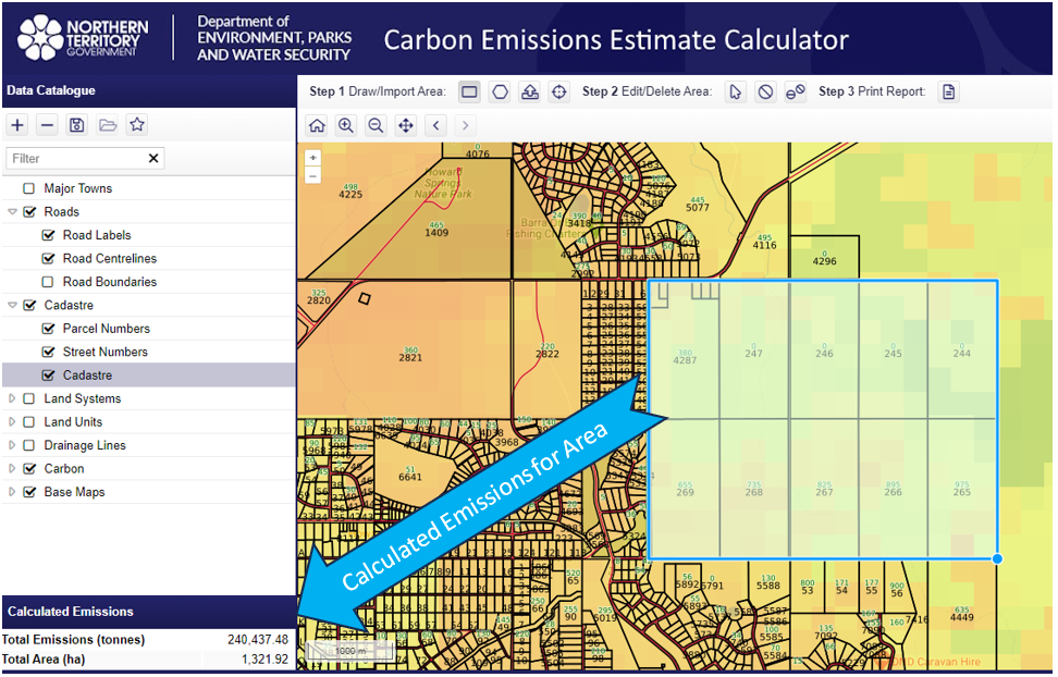
Cohga is pleased to announce the release of a new raster inquiry utility designed for the Weave platform. This utility allows users to perform raster statistical calculations using vector data inputs, offering practical applications such as measuring carbon footprints or flood heights in specific areas.

Configurable Capabilites

As with other Weave utilities, users have the flexibility to customize the tool's functionality through XML configuration settings. Currently, the Weave Raster Inquiry Tool is compatible with Oracle and PostGIS raster databases, and it can be easily adapted to work with other raster database systems like ArcGIS Image Server. This adaptability allows users to configure the tool for various calculations across different datasets, potentially spanning multiple database systems.

Example Site

This utility has recently been deployed for public use by the Department of Environment, Parks, and Water Security in the Northern Territory. They are utilizing it to measure Greenhouse Gas Emissions in designated areas, contributing to sustainable land management efforts. You can explore this system here https://nrmaps.nt.gov.au/carbon/carbon.html.

Summary

The release of the Weave Raster Inquiry Tool brings a useful resource for conducting raster calculations within the Weave platform. This tool offers flexibility for a wide range of tasks, from environmental assessments to geographic analysis. Its capacity to adapt and its practical use in environmentally important projects underscore its value across diverse fields.

Contact Us for further information about the Weave Raster Inquiry Tool.